-
Stay-Away, Okay?
Welcome to Utrecht! The second to last city on our European tour. We stayed at the Stay-Okay hostel (that is why the title is the way it is I am not mad at you, I promise!).

There was much to see in Utrecht. It was quite the cool city. Our first introduction to the city was this bubble structure featured above. We got off the train and there was this tall covering that protected commuters coming from the train station from the weather. The structure seemed to direct traffic into either the mall or the downstairs bicycle parking garage.

As already discussed, it was really cool to see the connecting of networks with the bicycle parking outside of the train station. Many people work in Utrecht, but even more people work or study in Amsterdam, which is a 30 minute train ride out of this station- an important connection point. In The Netherlands, citizens use one transit card which is accepted at all transit systems. Essentially, you need one card to get on the train, bus, tram, etc.
One thing that we discussed was the importance of offering multiple ways to get to a place. A biker can take 3 different routes to get to a place and all are safe, efficient, and enjoyable. I think this is really important- maybe we need to consider creating more roads instead of wider roads- give traffic different places to go.

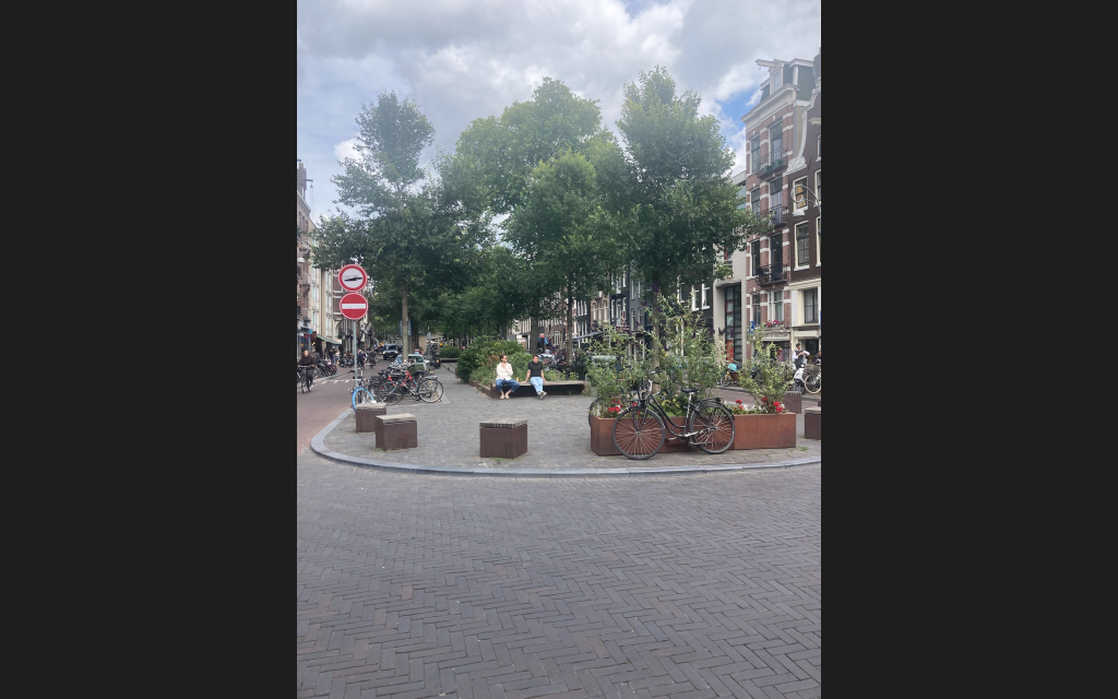
Above is probably one of my favorite things- a soft median (I named it that). This is a two way road with bike lanes on both sides. Essentially, a car can comfortably traverse the middle lane with bikes on both sides of it. IF a second car from the opposite direction is on the street, the cars can yield to the bike traffic and then enter the bike lane to allow the other car to pass. Design solutions like this require a lot off different factors- a low volume street, a trustworthy culture, slow traffic, and a smart user population. So, America could never. Anyways, such a cool road!
After Utrecht, everyone started to get Covid, so that is why I said stay-away, okay?
With Love,
McCall
-
Meet Me in The Middle
With the implementation of more bike infrastructure and other public transportation networks, less cars will be on roads. With roads being trafficked by less cars, an opportunity presents itself. Former road ways can be taken back and given to the public.
In Utrecht, you would have never known that a canal had once been a busy car highway. Now the space has transitioned into a green space and given back to the public. Public spaces are important because they can be different things. These spaces can be a place for community gathering, play, and/or exercise. Pedestrians often have the right of way in these areas and serve as an important connection between noise and residential areas.
A public space dividing traffic in Amsterdam You cannot just take back space and give it to the public. But hopefully as more and more cars are taken off the road, more space can be taken back. It takes time, something that it feels like we don’t have much of.
I just saw some cute boys sitting at a communal intersection, so I had to note that infrastructure obviously works.
With Love,
McCall
-
The Left Hand Turn
Okay, so this is some real bicycle nerd stuff. But essentially, it is difficult to properly engineer a left hand turn for bikers. In theory, it seems simple enough. You can just have a left hand turn integrated with car traffic, but it isn’t that simple. Bikes need to feel safe when turning, and most of the time a left hand turn on a car centered network is just not going to work due to the car being the honored primary mode of transportation.
In Denmark, you cross like a pedestrian would cross, you stop and wait in order to go again. This still seen here in the Netherlands, but it is less frequent. Bikers are the respected on the road and can filter in with road traffic. But–that is not how it still done. Bikers have their own lane and their own light to make their left hand turn! This way, a biker feels like a respected ‘vehicle’ on the road. In order to make a commuter feel important, proper infrastructure needs to be implemented for said commuter to feel safe. Furthermore, a commuter deserves to be prioritized. Networks need to be improved to be more efficient. By implementing design solutions that allow for a left hand turn, a biker can stop less!
It is important to limit the amount of stops that a biker takes. Creating networks that are continuous is important to encourage people to become cyclists. When a route continues, it is safer and more efficient. People will ride their bikes because it just makes sense to ride them over taking a car or bus.
Not everything here is perfect. There continues be change in infrastructure. Not everything can be streamlined and the same at every intersection. While traffic rules remain the same on all roads, intersections can be different depending on how trafficked an intersection is. Some roads are made to be mixed networks, and some networks can be completely divided (a road for cars, a road just for bikes, a road just for pedestrians).
Engineers really analyze each intersection because each has its own needs, and can be different from the one before. By addressing the needs of individual intersections, roads, and/or networks, it allows for greater efficiency and safety. A traffic light in a busy city center should not look the same as one found on a neighborhood road.
With Love,
McCall
-
I heard white wine heals sunburns
We were in Svendborg for a very short amount of time. The first day I had the dramamine fiasco and then the next day went to Aero Island via ferry.
The ferry ride was very cool because we were able to bring our bikes with us. We rode our bikes onto the ferry just as a car would drive onto one. We rode on the ferry for about an hour ride before docking on the small island. It was very picturesque. I feel like people would come here for the weekend, short vacation, or wedding. It was just so quiet. It is a great example of a cheap fun day trip.

After a 26 mile bike ride around Aero Island It was a really cool day. We followed a bike route (route 91) where there was long stretch stretches of protected bike lanes. It was a great example of rural bicycle infrastructure. The only downside is there were paths made up of pebbles for long stretches making it difficult to bike up and down hill.

The view from Aero Island By the time the Ferry docked, it was evening time and there was an event down by the harbor. I cannot remember what the event was called, but it was a true spectacle. There were kayakers in the water with fog machines, drones flying in puppets, a live orchestra, and giant puppets!
The next day we biked to Korinth, a very small town! The bike ride was another long one. It was really beautiful, so totally worth the mileage. From Korinth, we went to Odense. We biked the rail trail ( a narrow, flat trail alongside old rail tracks) to the nearest train station. We were able to take our bikes on train! Which of course was really cool! We took the train right into Odense, hoped off the train and biked right into town for lunch! If only life in the U.S. was this easy!
With Love,
McCall
-
“Get in loser, we’re going shopping”
Look if I could fit Denmark and The Netherlands in my bicycle basket and take them home with me, I would. Although, customs might have an issue with that.

From the walking street in Copenhagen So what would I take and bring back to the U.S. from each country?
First, the green space found in Copenhagen! There was so much green space in Copenhagen. Streets were quieter at night (except for the high school students celebrating their recent graduation) because people seemed to swarm to the park to meet up with friends, be with their families, or get in some evening exercise. No matter the time of day, someone was in the park.
Secondly, I would take the timed traffic light system in Copenhagen, there was no need to press any button to ask to cross the street, a timed light controlled all the different forms of traffic.
Third, the metro system from Amsterdam! I did not ride much of the metro much in Copenhagen, so I had to go with the Netherlands. Recently, transportation experts have foregone rowed seating in their metro cars and transitioned to having benches along the sides and the center free for more standing space. There are no more doors between cars, so passengers can see all the way down to find a place to sit.
Fourth, I would say the soft medians found in Utrecht. When roads where made to be more bicycle centered, designers created a ‘soft median’ or a bump in the road used normally to separate two way car traffic, for cars to pass over if a bike is in the road.
Fifth, the cycling highway that we saw in Nijmegen. Something that I witness was much of Denmarks’s bike networks tended to drop off or stop at certain roads, and you didn’t know how bike friendly a road was. In the Netherlands this isn’t really a problem, paths continue longer, and connect to rural towns easier. Bikes are more welcome on roads because it is so engrained into the culture.
Sixth, the people in Denmark. The people seemed to be much kinder and willing to strike up conversation in Denmark, especially in Copenhagen. However, I would say that in the Netherlands, there is a lot more eye contact and acknowledgement of bikers on the road.
Seventh, the traffic lights in Copenhagen. In Copenhagen, the bike traffic lights are located in front of you, and right where you wait before crossing a street. There are at least two lights located at every point that you may cross a street. The light will also turn yellow before turning red. In the Netherlands, there is a light located at your eye view where you press the button, so the person waiting at the intersection has to look down at the light instead of ahead.
While both countries have so much in common, they do have their own way of doing things. Biking in each country is so different, but an experience that I will never forget. It is not even equatable to biking back in the U.S. The bicycle infrastructure offered in both countries is truly incredible.
Nothing is perfect, but people that care about sustainability and accessibility are working on viable design solutions. I am so aware of what is possible now and what can be accomplished with successful design.
With Love,
McCall
-
Follow The Red Brick Road
We made it to the Netherlands- just barely. I am kidding, it was a very pleasant 9 hour drive through Germany. I didn’t take Dramamine this time, which was a good idea–saving that shit for the plane ride home.
Anyways, on our way into the Netherlands we encountered a road blockade due to farmers protesting the nitrogen regulations issued by the government. Essentially, the government has a very comprehensive climate change plan (for people at home, climate change is when.. I am just kidding), and in this the government said they would greatly reduce emissions from farming, but they have not outlined how they would do so yet. I write this because I think it will be important to watch and follow what the Netherlands do in response–will they subsidize sustainable technology options to farmers, will the government take away land, and/or will farmers lose their jobs?
Back to bikes! While in Nijmegen, we were introduced the Cycling Highway. The Cycling highway is a comprehensive bike trail network that connects rural neighborhoods together. Different cities were involved in developing cycling infrastructure to run through multiple municipalities that all connect and lead into the city of Nijmegen and beyond. A continuous path was constructed with no pieces left hanging. Trail networks are like pieces to a jigsaw puzzle, and if you lose one then you leave a cyclist in the middle of nowhere. Planners took a small amount of money from highway and other road funds (small in comparison of how big road infrastructure budgets are) and built roads centered for bikes. These roads are red in order to signal users that bikes are the primary honored mode of transportation on this system. Cars can go on these systems, but very few. The red road continues all the way into Nijmegen where then the bicycle lanes are red for continuity.

Creating dedicated and separate paths for cyclists only increases how safe and welcome bikers feel within a space; while also allowing other users to understand a system and honor the rules.
With Love,
McCall
-
It’s a Beautiful Day in the Neighborhood
A beautiful day for a neighbor. Would you be mine? Could you be mine? Won’t you be my neighbor?
Welcome to newly built suburban neighborhood, Houten. Houten is a new development, built to address the housing shortage and increased interest in suburban developments. Planners had the opportunity to develop a community from start to finish with a fully developed plan of the town before ground was broken. They had full control over the placement of roads, bike paths, homes, restaurants, medical resources, etc.
The development didn’t look sleek or modern or have plants growing everywhere like you were probably envisioning- or not, which is totally fine, but you might lack an imagination. It just looked like a regular housing development, but with an efficient bike network that connects homes, resources, and parks to the city center.
Providing public transportation infrastructure allows for communal growth and connectivity. Furthermore, access to a network of transportation options allows for children and teenagers to experience freedom and independence. Transportation dictates much about our lives. It dictates how we will get from one place to another, maneuver a city, how safe we feel, and how much time we spend commuting. By providing an efficient bike path network -meaning: leaving no holes, or dropping off anywhere- residents are easily able to bike to the store, to the swimming area (yes, they had a swimming area and it was lovely) and to the city plaza.
Personally, I don’t much care for the suburbs. I grew up in one, and while I love my hometown, I pray for the day where I can take a red sharpie to it and change it. The suburbs for me have always sparked an interesting debate. Towns are supposed to be accessible, but the suburbs are not. I still remember how excited I was to get my drivers license at the age of 16 so I could finally drive to my friends’ houses or to school. Without a license OR access to a car, I would have not been able to get around.
To me, suburban developments are a very westernized concept; adapted to be apart of the American dream. Historically, towns and cities were built to be dense because it was safer and easier to get around. Towns were constructed along geographical features that provided industry, food, and life; like rivers, lakes, valleys, and oceans. Once cars and trains were developed, things rapidly changed. Cities were no longer clean, safe, and desirable to be in. So suburban developments were constructed in response to hoards of people leaving cities in search of a better life.

The VEGAN and GLUTEN FREE pancake I ate after our 30 mile bike ride to Houten My concern is for developments to start being built anywhere and everywhere. You cannot just transplant a development (even if it is sustainable) anywhere, and hope things work out. There needs to be an industry, a culture, and desire to be there. Furthermore, suburban developments are normally only accessible to the rich due to housing prices being expensive in these areas. Suburban developments may address housing deficits, but do not work to bridge economic and racial gaps, due to developments often not providing affordable housing options.
I think planners and policy makers need to consider these things before moving forward.
Houten is a prime example of what can go right with the implementation of proper infrastructure. While suburban developments are problematic and riddled with sustainability issues, Houten is a step in the right direction, and a suitable design solution for other suburban cities to adopt.
With Love,
McCall
-
GARAGE **in an english accent**
When the majority of your country bikes, there is gonna need to be space made for when bikes are not being used. You know, like how cars get giant parking lots? Chaining your bike outside a restaurant or a grocery store is temporary, but what about when you go to work, or you’re looking to spend the day in the city shopping? Shouldn’t bikes get something just as cool as cars? Like parking garages? Well, what about something a little fancier, like swanky underground parking structures?
As we know, finding space in a city is very difficult, and quite expensive. Shop owners are reluctant to let go of parking spaces due to concern for their business. Ironically though, most parking spots in front of shops are being filled by someone who isn’t even contributing to the business it is parked in front of. And with a spot or spots always being filled, people will choose to not shop there because there is no available parking. But with bike parking, you can fit way more bikes in a car sized spot than just one car. Which leads to more customers visiting or being able to access a business.

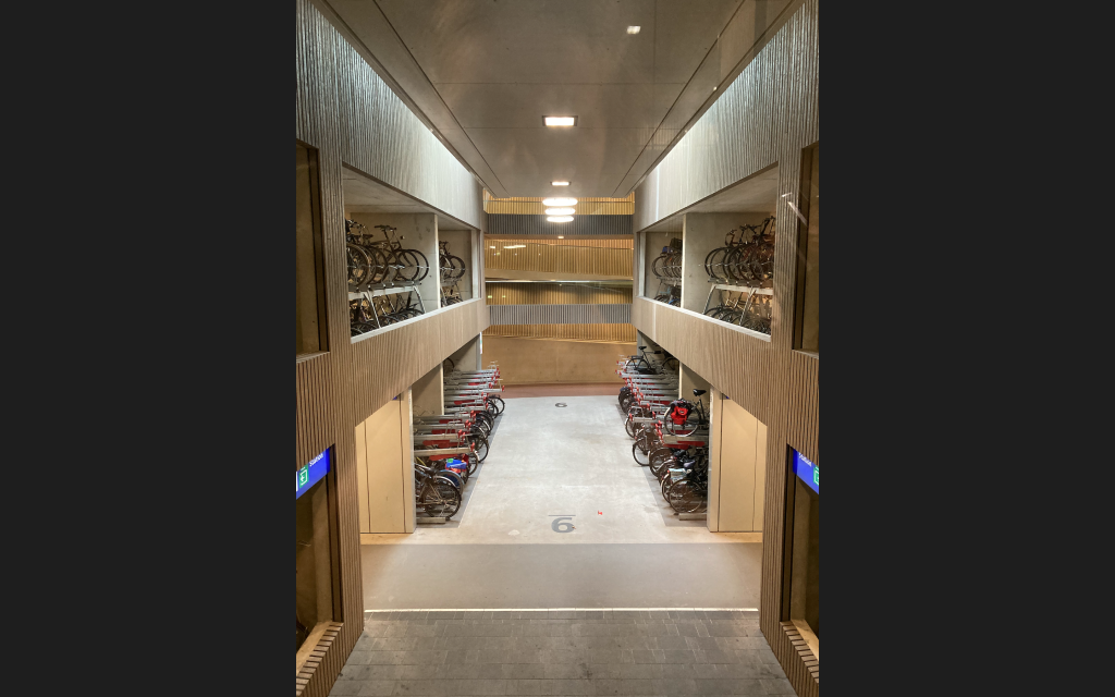
The Netherlands has decided to solve their bike parking problem by creating underground parking garages for bikes. In the process, above ground car parking spots are not taken away, and more people are able to access a space. If these parking garages are strategically placed, thousands of bikes can be parked in them.
While in Utrecht, we toured one in front of the train station and mall. The garage had the capacity to hold 2,500 bikes. The facility was a really nice! They all work differently. Most are free for the first 24 hours and then overnight parking costs extra. There was security inside– you know, for when someone tries to smash the window of your bike to grab your purse from the backseat.
Creating proper infrastructure to address the increased use of bikes is important. While biking may be easy due to the protected lanes and the overall biking culture, bikers still need a space for parking and storing their bikes.
With Love,
McCall
-
POV: You’re A Pedestrian
Something that a designer has to consider is the audience that they are building for. What perspectives are they constructing a space at, who can use a space, and how will different people groups interact with a space?
It’s all about the scale at which you design a space. For example, the height of windows for a business front are important because people need to be able to see into the window. The window height will have to be designed low enough for young children to see through the windows, and big enough to catch the attention of someone walking by.
A pedestrian interacts with their city in a specific way. They have the opportunity to walk alongside restaurants, through plazas and shopping squares, and alongside canals and parks. In my opinion, pedestrians can interact more with their given space. They can see more of what is around them because they can pause, turn around, crouch down, touch, smell, etc. They can walk in and out of shops, smell things, be attracted to specific colors, and explore.

A pedestrian’s ability to interact with a space is based on whether the space is safe and the designer took into account different user needs and abilities. At the end of the day it is all about accessibility; and whether design fosters independence. Furthermore, a pedestrian needs to feel safe in order for them to use a space. That is why pedestrians may advocate for a buffer between a sidewalk and busy street, a protected crosswalk, and private pedestrian trails arranged away from busy streets.

Hooks were installed outside buildings for people to attach their dogs to (temporarily ofc) A biker’s perspective is pretty interesting too. Biking is used more to get from one point to another. So in order for a biker to be able to get somewhere efficiently, bike lanes and traffic rules need to be established. Once a biker can get around safely, they don’t stop like pedestrians can, but they can still take in their surroundings. Bikers can go where cars can’t, and are exposed to the outside ‘world’. Bikers can bike past restaurants and engage more with pedestrians.
When driving in a motorized vehicle, you are focused on reaching a destination safely. You are looking for different landmarks, signs, and lights, that tell you where you are going. Way-finding is important at every stage, but it may look different depending on the user. A car interacts with traffic lights, road barriers, street signs (at car height), etc. Statues, parks, historic sites and buildings are used as tools to find your way around a place.
I am noticing that I perceive a space differently depending on whether I biked or walked through it. I take note of different things in order to find my way or navigate through a space. Details like a cat in the window at a restaurant, or the house on the corner that is blue.
As always, just some thoughts.
With Love,
McCall
-
Thomas and Friends
I am starting to understand the childlike fixation with trains that both my brothers had when they were 4. They wouldn’t stop talking about Thomas and his friend’s Percy and James. With every passing train, my parents would shout, “Say Hello to Thomas!” and they would absolutely lose their mind.
I think I am starting to have the same excitement and fascination for trains as my brothers once did. I can’t help it, the trains here are just so gosh darn cool! You can hop on a train and get where you need to go just as fast as traveling with a car. We have travelled multiples times by train while being here, and I find it to be a really important part of infrastructure and reducing traffic issues on highways.

Metro stops labelled with connections to tram and train routes. Having light rail and metros in cites helps with reducing vehicle traffic and meeting accessibility needs. Offering light rail and/or metro routes in and around a city greatly increases connectivity and allows for all age groups to have a sense of independence. Furthermore, offering a quick transportation option, like light rail, that connects rural cities to neighboring urban hubs (where jobs and school is located), is important for commuters, students, and young people. Here, we observed the installment of a rail network from the rural neighborhood Houten to urban city Utrecht. For my people at home, this would be like connecting Folsom to Sacramento with train that runs every 8-15 minutes, that is reliable, efficient, and takes into account accessing station stops by bus and/or bike.
Rarely do all transportation networks connect together, but this is something that is really important, and is taken into account here. People need to be able to access rail stations, bus stops, and bike paths. Outside the main train station in Utrecht, a large awning covers a pedestrian plaza to feed commuters either down into the bike parking garage down below or into the adjacent shopping mall. In Odense, city planners do their best to consider every user. Bike paths are used along main roads, bridges, and parks. Pedestrian only areas exist in plazas and shopping streets. A light rail and bus system connects residents to neighborhoods and the city center. While, cars have underground parking and limited roadways to reduce use and sound.
With good transportation infrastructure on every level, a community can experience effective growth. One transportation system is not effective without the other; each depends on each other fiercely.
With Love,
McCALL
-
Subscribe
Subscribed
Already have a WordPress.com account? Log in now.
